Showing posts with label geography block. Show all posts

Monday, March 12, 2018

Waldorf Grade 5: Ancient Cultures Block

  Our second block of the fifth grade school year was Ancient Cultures, which combined language arts, history, social studies and geography.  As an aside, anytime we are not in a math block we always start our day with some math practice on the board, so that those skills do not get forgotten.

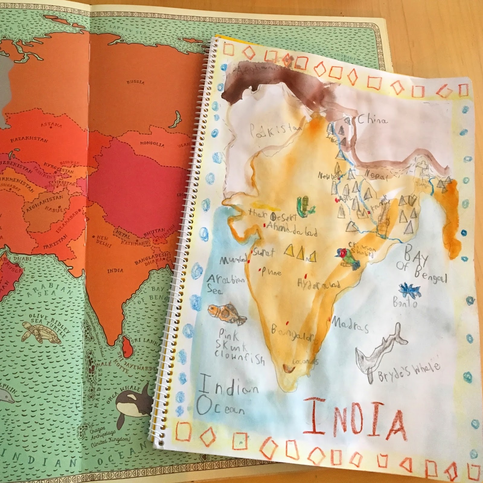
  Our first area of focus was India and it covered two weeks. As usual, we began by mapping India and studying the indigenous plants and animals.


 We learned the origin story Manu and the Flood.  We found references to Atlantis and compared it to Noah's ark.  For any of the myths or history stories, we follow a two day schedule of learning.  On the first day I tell the story, usually with a chalk drawing I have prepared, and Jack will make a main lesson page drawing.  On the following day he will retell the story, in his own words, while we work on language mechanics.  Some days he just writes, but if it is a complicated story I may help him make an outline first to make sure we don't leave out any crucial information.  


 We found a beautiful version of the Ramayana in the book A Year Full of Stories.  We really enjoyed learning about the faith of India through the Bhagavad-Gita and comparing it to our own values.

\

 Since the boys are in the school room together, they often hear parts of their brother's main lessons. Will was halfway paying attention to the story of Rama and Sita when he heard mention of the Monkey King, Hanuman.  I guess the idea of a Monkey King proved irresistible to Will and he immediately had to drop his own project and get his vision on paper! This is one of my favorite things about homeschooling: that we have the space for this kind of work.


 Our third week of study focused on Buddha.  Again, we compared our own values and faith with The Eightfold Path and the Noble Truths.


  For our final week of study, we spent the first day mapping Persia.


  The following day we covered Zarathustra.  Again, this was a great opportunity to compare and contrast all of these world religions with our own.  How wonderful to see so many core values in common.  


  Later in the week we looked at Xerxes and the wars with Greece.  Jack is excited to get to the Ancient Greece block (thanks, Percy Jackson!), so he was eager to hear mention of Sparta.  We may have taken more of a Greek focus than was intended, but it's nice to have the student so eager!


Waldorf Grade 5: Geography Mini Units

  The first block for Waldorf Essentials Fifth grade combines mapping, geography and history.  We started with a review of US Geography, learning which states were in each of the four regions and remembering capitals.  This took us through the first week of school, studying a new region each day. For each region Jack made a main lesson page that listed each of the states and their capitals.  We worked with some map puzzles and even played the Stack the States app on the iPhone (the horror! So very un-Waldorf!  Yet, so very effective in this instance!).


   We studied Africa for the next week, mapping the continent and reading about the flora and fauna.  


 If you have ever used Waldorf Essentials before, you will know that the curriculum can often be a suggestion about what to focus on for the daily lesson.  Personally, I love having this framework and tailoring the lessons to fit the child.  It does mean you will need some extra resources, many are suggested by Melisa (especially in the grade overview audio recordings on her site).  The extra resources we use are normally wikipedia pages printed out, examples of main lessons found on pinterest and library books.  We have managed to build a pretty good home library over the years and I was able to pull several books to help with these units.  Here are the bulk of them:


 The Monkey and the Fiddle was our choice for the folk tale. Jack did a great job on his first summary of the year and took great care with his border and drawing.  We try to follow a two day Waldorf approach to Main Lessons,  listening to the story on the first day and then modeling or drawing from it.  On the second day, after the story has had time to digest, we write a summary.  We usually discuss it first, to make sure that we remember the important characters and events.  I will put proper names on the board to help with spelling, but Jack writes it himself.  When he is finished, we read through it together to catch spelling or grammatical errors.  I'm a big fan of focusing on a few items at a time, as I gleaned from Julie at Brave Writer.  For example, we may discuss the following: run-on sentences, proper nouns start with a capital letter, and sentences end with a punctuation mark. I'll have Jack look for those items on his own and try to limit any critiques to those specific areas.


  To wrap up the Africa block, Jack cooked an African feast for us, using this Moroccan Chickpea Stew recipe


  Our next mini block was Atlantis.  This definitely seems like an odd choice, but it is typical in the Waldorf fifth grade curriculum.  We talked about the legends, specifically Plato's writings about it, and where it may have been located. We also looked at maps drawn from Plato's description and made a clay model.  Like the other areas of study, we also looked at animals and plants.


  Our next stop on the mini world tour was Australia.  Aboriginal folk tales combined with exotic plants and animals mad this a really enjoyable unit to study. I am so glad we found out about the book Topsy-Turvy World: How Australian Animals Puzzled Early Explorers by Kristy Murray from some Australian homeschoolers on IG.  Reading about the European explorers' first impressions of animals such as the platypus and wombat was highly entertaining.  He chose to write about the kangaroo from the fifteen species highlighted in this book.


  Our geography block really set the stage for a fun school year.  We got a little busy and didn't plan a meal for Australia, which was a shame.  It certainly adds a lot to the unit and Jack is so proud to take charge of a family dinner.  Jack's map making skills improved greatly this month, as did his world geography knowledge.

Thursday, December 1, 2016

:Waldorf Grade Four: {Geography Block}

  Somehow 2016 is nearly in the books and I still haven't had time to post about what we've been up to for the first semester.


  Jack's first block of Main Lessons from Waldorf Essentials is Local Geography. We started with drawing maps of our home, our street, our neighborhood, city, county and, eventually, state.  I really like how Waldorf Essentials provides a basic framework for lessons (and weekly form drawings and some writing practice) but leaves some room to customize them to fit your own needs.

Jack adding rivers and highways to his NC map
  We added in some local history by visiting Big Rock Park, which is conveniently just a few miles from us.  Nomadic groups of Paleo (or Archaic) Native Americans used this site as a campground dating back 12,000 years.  The gigantic rocks provided shelter from the cold winds that blew across the ancient grasslands and made great lookout points as the clans followed herds of big game.

Learning about the abundant tree nuts around the park.
Big Rocks are awesome!

We traveled to Winston-Salem for the Old Salem homeschool day to learn about the Moravian settlers who founded the town in 1766.  The boys were able to see demonstrations about gardening, rifle making, dyeing, hearth cooking and furniture joining. They got to make marbles from the clay that is dug up in a nearby creekbed, sample hot chocolate and cinnamon water as well as try their hand at writing with a feather quill and ink.  They had a really fun day and really got a sense for the life of an eighteenth-century settler.

Visiting a recreation of a typical kitchen garden
  In addition to drawing maps of the world around us, we also learned about map reading.  I used the Montessori three part (or nomenclature) cards to help us learn terms.  For fun we used our Safari Toobz World Landmarks and Around the Globe with these cards.  The cards don't quite match every landmark from our sets so I made a few more cards by finding a blank template.  The boys got the terms down quickly (yes, this activity was so fun the second grader joined in too), and worked together to plot out the landmarks.  We followed this blog post and used Google Earth to find the latitude and longitude of each landmark and then place it on the big world map.  They worked on the Great Wall of China first and were surprised that their coordinates led them to North Carolina!  They quickly realized that the Google Earth search found a local takeout restaurant instead of the actual Great Wall.  It was a great exercise to emphasize the importance of the East/West and North/South designations on the coordinates.  All three boys loved matching the landmark figures with their three part cards.